
SAR in BC for UAV operators
In my ongoing series about the operational use of UAVs for Search and Rescue, today I’d like to post about how a UAV operator can understand how Search and Rescue in British Columbia works, and where UAV operations fit in.
The first thing to consider when trying to understand SAR is that a joint program between the BC Search and Rescue association and the Justice Institute of BC created the online course SAR 103: Introduction to Search and Rescue in British Columbia. The course is free to take, and many SAR teams recommend that members who want to volunteer for SAR take this course so they know what they are getting into. I have not personally taken the course and would appreciate your opinion on it. To quote from the curriculum;
This course provides a valuable overview of the Search and Rescue (SAR) model used in British Columbia (BC), and the roles and responsibilities of each component in the SAR structure. This course complements the Ground Search and Rescue volunteer training modules currently provided through the Justice Institute of British Columbia (JIBC), and includes examples of typical SAR responses.
A second course you might consider taking is Incident Command System Level 100. This course is an introduction to the Incident Command System, or ICS, the management system that almost all emergency response agencies in North America use. SAR managers in BC are trained in the use of ICS to manage all incidents. To quote from the curriculum;
Learn a proven incident site management system for emergencies or disasters. Students will be introduced to an effective system for command, control, and coordination of response at an emergency site. The Incident Command System (ICS) is recognized as a flexible and scalable all-hazards system, which provides a common response framework suitable to any size of event. Gain a basic understanding of the Incident Command System, its organization, principles, basic structure and common responsibilities.
There is also a very good overview of ICS at ICS Canada.
The integration of emergency responders, including SAR, is covered under the BC Emergency Response Management System (BCERMS) that addresses the integration of emergency management and its role throughout the province. There are two documents; a presentation and a manual. Pretty dry reading but it gives you a comprehensive view into the the viewpoint of emergency management in BC.
Finally, there is the Emergency Management in BC Reference Manual from EMBC. Probably a bit too in depth for most people, but publicly available and useful to gain a greater understanding emergency management from a provincial perspective.
Operations
So in my view, where do UAV operations fit it?
A UAV is an aircraft, and it is covered under Transport Canada Canadian Aviation Regulations (CARS). As such, it’s place in the ICS structure is in the Air Operations Branch of the Operations Section, under control of the Air Operations Director, who reports to the Operations section head.
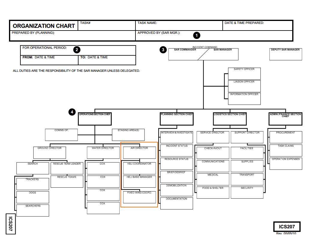
This make sense because the UAV should come under control of an air traffic controller (ATC), and be integrated into the planning for other aircraft. Consideration must be given to where aircraft are operating, division of airspace to remove the possibility of collisions, and control of a landing zone (LZ) – most likely one seperated by some distance from other aircraft. UAV oeprations must be in constant contact with other aircraft just as pilots using air to air frequencies coordinate their movement. Strict use of the command net, and inclusion of the ATC must be enforced so all air assets know where the UAVs are operating.
Consideration must be given to real time position reporting for all air assets so a ground controller can notify of possible conflicts.
Most operations that involve both unmanned and traditional aircraft would segment the search area by region or elevation so no interactions are possible.
Current Situation
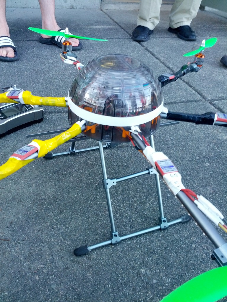
As I mentioned in my last post about UAVs in SAR, Transport Canada and been unequivocal in their assertion that any use of UAVs that is not for recreation requires a Special Flight Operations Certificate. This means you cannot, as a hobbyist, “volunteer” to fly your UAV for SAR because it is no longer recreational. Search and Rescue teams are unpaid professionals, and are familiar with safety regulations and certifications processes, and none of them are likely to even consider the use of a UAV unless they can do so on a safe, approved and regulated manner.
Any operator will also need to carry insurance and demonstrate an operational safety plan.
Also, Emergency Management BC has, to date, refused to authorize the use of UAVs for SAR work, although I understand there is some consideration of the technology happening.
I will be continuing my series of posts on the use of UAVs in SAR next week with some scenarios for where a UAV would have been useful. I would appreciate feedback from anyone in the UAV por SAR community on any of my posts.
Good morning,
I have some ideas to share on this, please read below.
Posting the UAV Team under the command of the Air Ops Officer is a good idea. Situational awareness of all air vehs and ground support cannot nor should not be separated into multiple tiers of the hierarchy.
This does, however, raise the question of data management of the UAV feeds. Different needs from different teams equates to different platforms and various ways of managing the information. Some key questions:
1) What is the overall intent of the data? Is it to provide an electronic record of the operation (strategic level information), provide overall situational awareness to the IC (operational level information), or to provide the Crew Leaders a bird’s eye view of the immediate ground around them (tactical level information)? Each level of information would need to be managed differently. A basic overview of some concepts for each are below (as examples; to note is that none of these are mutually exclusive):
a. Strategic Level. Record the operation. Provide record for review for future
training, as evidence for any investigations, and for archiving operations.
This type of information could and should be managed away from the IC,
as they will have enough to manage. A data feed and recording/archiving
set up could be managed by a UAV team lead under the Air Ops Comd;
b. Operational Level. Arguably the most useful form for operations of this
type. Providing real time video feeds to monitors in the CP would empower
an IC with information to make decisions–such as vectoring ground crews
to “hits” from a UAV, managing the scene and search area (hot and warm
zones), etc. Platforms deployed and managed through Air Ops, with data
feeds managed through an Air Liaison Officer who is attached to the
headquarters. This way the machine is handled through the proper
channels, and the information from the machine is provided in a timely and
effective manner to the IC.
c. Tactical Level. Ground crews with mobile devices can be linked to UAV
feeds. Combine this feed in their hands with the same feed going to the IC
in the CP and you have synergistic enablers. IC can make calls to ground
crews with big picture items, ground crews can provide real time feedback
with info that the UAV cannot pick up.
To address multiple users in an air space, a simple way for the Air Ops officer to manage would be to enact a form of on demand control measures. For example–a UAV crew is being deployed to an area. A ROZ (Restricted Operating Zone) request goes in from UAV commander to Air Ops officer, detailing time to open, altitude, diameter, and anticipated time of closing. The UAV does not go airborne until ROZ is approved. A ROZ approval would happen after the Air Ops team juxtiposes the ROZ request over the operational air space and looks for conflict. If none, ROZ gets approved and that “bubble” of air space is closed to all other air traffic while it is open.
Great work, I look forward to sharing more ideas with you. It would be amazing to see this concept go live.
Cheers
Bart Fyffe
Executive Director
Valhalla Geospatial Products and Innovations
Castlegar, BC
admin@valhallageospatial.ca
250.608.0339