
Personal Locator Beacons from the Rescuer’s Perspective
A case study of a recent rescue in Southwest BC
My SAR Team just completed a rescue of three stranded hikers in the DeBeck Creek area north of Coquitlam, on the west side of Pitt Lake. If this sounds familiar to readers of this blog, it’s because we were searching there this time last year.
The Initial Call
The call came in around noon on Monday, August 22nd
3 males on Fools Gold Trail. Left from Squamish side Friday. SPOT Triggered at 49 30 40/122 38 00
It turns out that it wasn’t a SPOT device, but a hybrid PLB (Personal Locator Beacon) operating on the 406 MHz COSPAS SARSAT band, and on the 121.5 MHz band. The device, which I will not name, may have also included a GPS which it used to encode it’s location into the distress signal. The satellite system, operating on 406 MHz, typically uses triangulation to determine the location of the beacon. The 121.5 signal can be used to alert aircraft that fly over the area, and can also be used by hand-held rangefinders to pinpoint the beacon’s location.
Unfortunately, the weather at the time was very bad. Southwestern BC was in the middle of a rainfall warning. Visibility was non-existent, with clouds at sea level, so flying in to the reported position was impossible.
We immediately realized that we had no idea why the subjects had activated the PLB, and unlike 90% of our searches we had a pretty good idea of where they were, and very few choices on how to get there. From our records of a search in the area in the previous year, a ground party had taken 6 hours to walk 3 km in that portion of the valley. Based on that rate, it would take 8 hours to reach the reported location.
SAR Managers took the call, and began the investigation phase. Contacting the subject’s parents, we discovered it was a party of three that had activated the beacon, and that they were on a five day hike through the “Fools Gold” trail in the Pinecone-Burke Provincial Park. We plotted the position given, and found it curiously far from the route, on the northeast side of DeBeck Creek at about 1120m, 520m above the creek. Using air photos, we could see what looked like cliff bands in the area.
Speculation on the condition of the subjects aside, it was quickly decided that the PLB activation had to be treated as all SAR calls are, an emergency. Based on the design of these devices it is highly unlikely that it was an accidental activation, so the response was planned. A team would be sent by boat up Pitt Lake and would attempt to walk in to that reported position. A second team would remain at the beach to provide backup, and communications in the remote area.
The Military
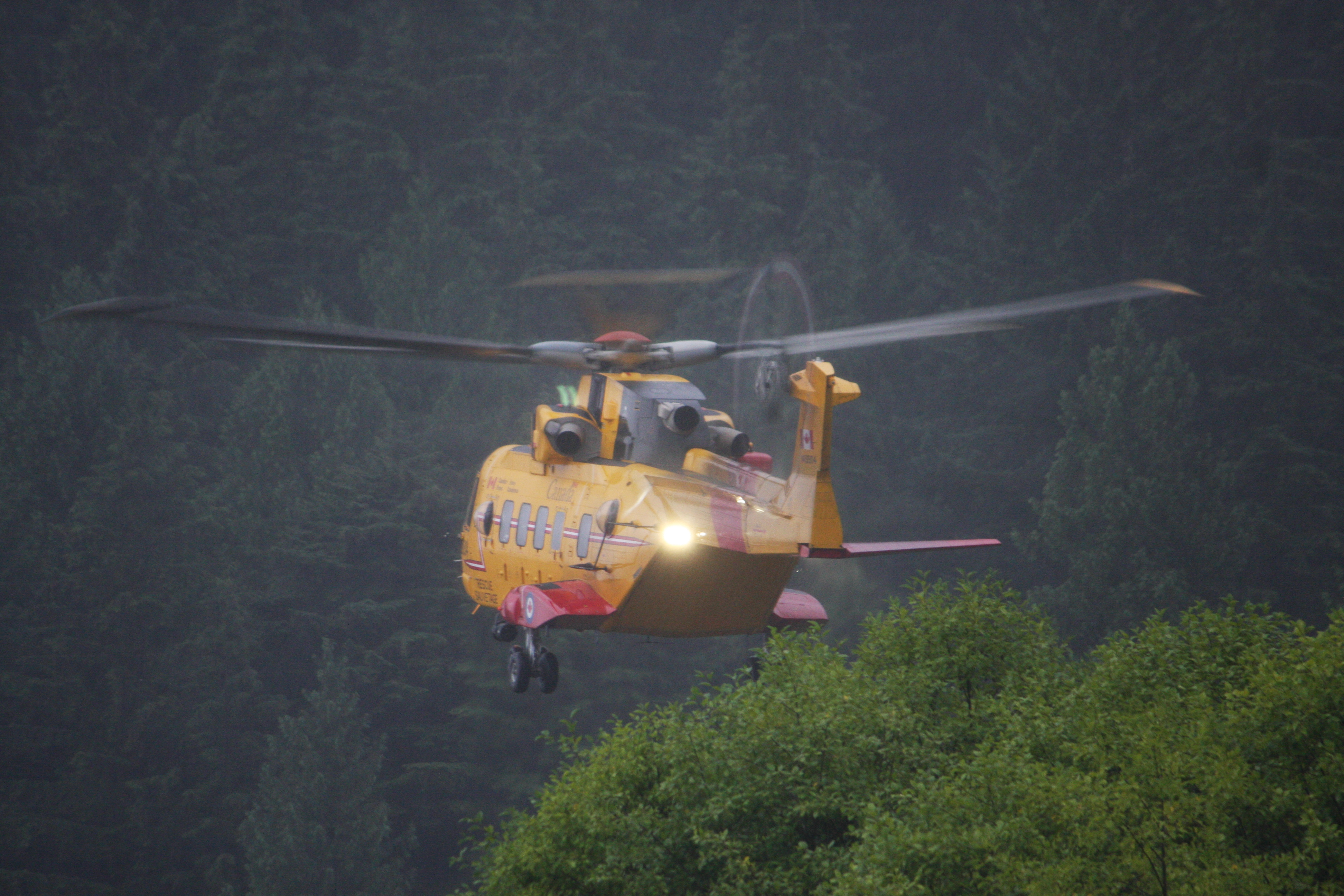
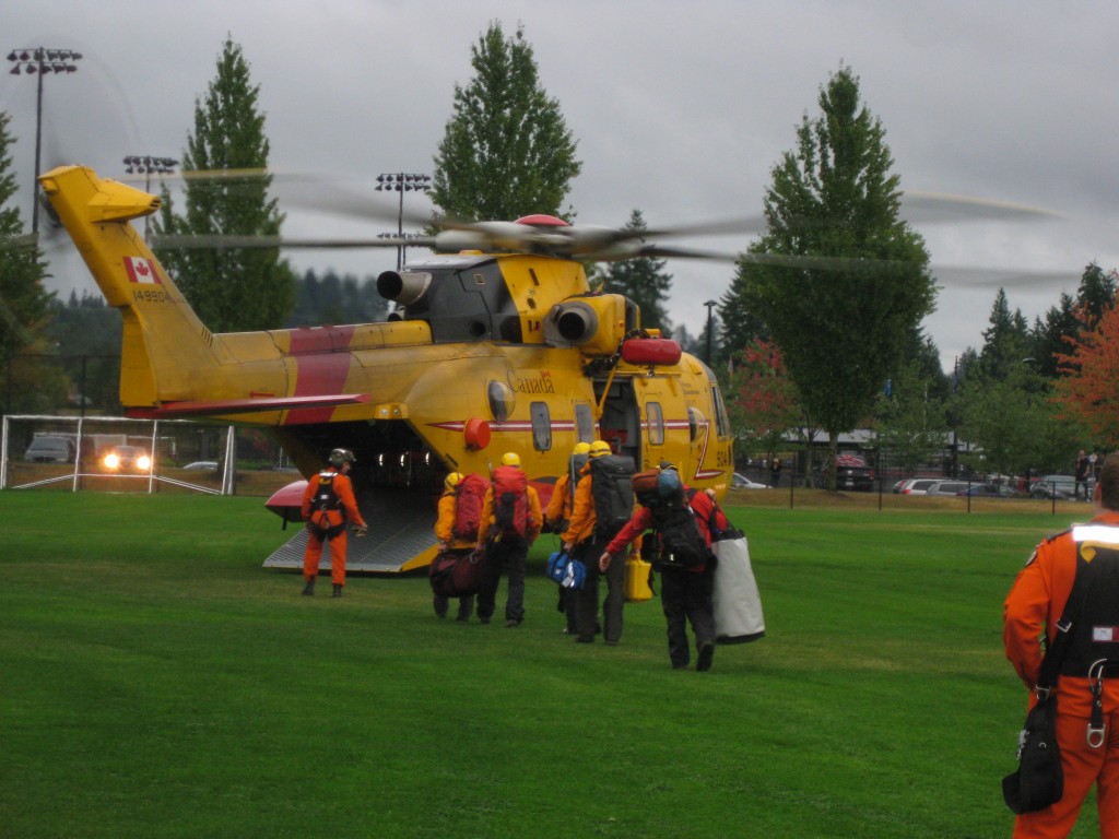
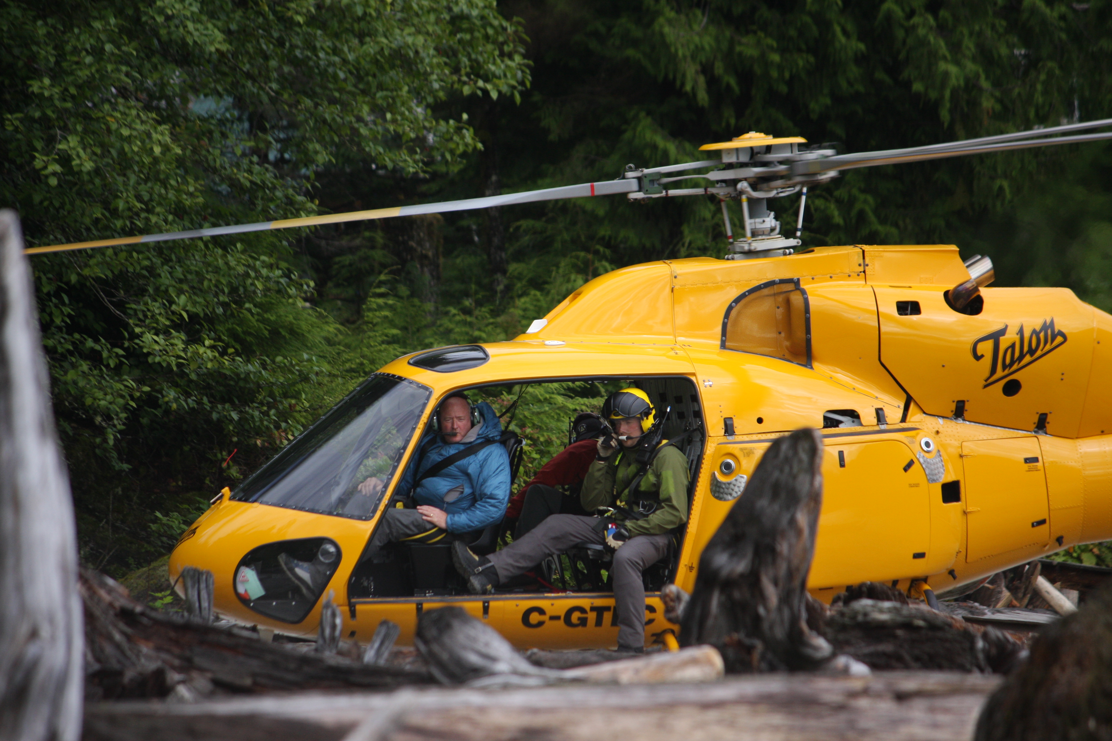
Of course that wasn’t the only plan. Whenever commercial aircraft cannot fly, we call in 442 Rescue Squadron, our local Canadian Forces SAR specialists. Using the CH-149 Cormorant helicopter they are capable of flying in much worse weather. It turns out they were available to fly, and made an attempt to reach the reported position. Unfortunately, the attempt failed, however, they did land and pick up our five SAR members, flew them to the creek’s outlet on Pitt Lake, and hoisted them into position just before dusk on Monday.
The Search
Late in the day, an updated position was provided by the Joint Rescue Coordination Centre (JRCC), the agency that liaises with the SARSAT system. To our shock, the reported position was almost 2 km southwest, across the valley and at 1200m, in alpine terrain. What to make of this? Given the terrain and the weather we couldn’t send the same team to both locations, we would have to dispatch a second team. This was an even longer hike than the first, and on the other side of DeBeck Creek.
The fundamental problem is that neither coordinate came with an estimate of the certainty, or possible error. If the second point was more accurate than the first we could at least decide to send more resources to that area, but there was nothing indicating which was more accurate than the other. So we abandoned our original assumptions about the first position being accurate, and fell back on standard SAR techniques.
In the mean time, much information about the subjects and their trip plan had been gathered from the family members. We received a detailed list of waypoints and directions compiled by the subjects, along with copies of the maps that they had taken with them. We had descriptions of the gear they had takes with them, their preparations for the trip, even how heavy their packs were, and the fact that they had taken flares with them.
The teams that were winched to the beach spent the night, and planned to start travelling up DeBeck creek at 04:00. Support teams were to be dispatched from Grant Narrows boat launch at 07:00 using an RCMP Rigid Hull Inflatable (RIB), and a second group to head up the southwest side of DeBeck.

Technology
In the heat of the search it is easy to believe that a position reported using an advanced system such as SARSAT would be accurate. However, reading about the system informs us that this is not the case. The satellite-based location fix is obtained from the 5 watt, 406MHz radio signal alone, and not using a GPS. It is accurate to about 5 km. This is the default operation of the PLB system.
If the transmitting device is also equipped with a GPS, which is optional, it can “piggyback” the GPS-derived coordinates in the radio signal. The accuracy of this fix depends on many factors: the weather, the tree canopy, the visibility of the GPS satellites based on the local terrain and their current orbit, and the hardware used to calculate the position. In addition, the amount of data that can be transmitted by the distress beacon, or bandwidth, is limited, so the precision of the GPS fix is truncated. This results in a best-case scenario of +/- 125m for the most accurate fix possible under clear conditions.
Aside: there are even more issues that could “confuse” the GPS portion of the PLB. For instance, most GPS units when turned on for the very first time, must download an ephemeris which contains information on what GPS satellites should be available. Depending on the hardware, this download could take as long as 15 minutes. This would obviously delay the time it would take for the unit to deliver a GPS fix. Also, there is some possibility that a device transmitting on 121.5 MHz can interfere with the GPS antenna’s ability to receive the GPS signal. There are more details on the issue at this site, which contains much more information on PLB/GPS issues than I could possibly summarize in this article).
The conditions of this search were far less than ideal. The DeBeck Creek valley in that area is deep, heavily forested and has significant terrain to the north and south, blocking clear views of the sky and the satellites. Additionally, the heavy rain and cloud cover could interfere with both the GPS satellite signal reception, and the 406MHz signal transmission. I suspect, based on our experience and the data (see map below), that the PLB didn’t manage to calculate a GPS fix until late morning on Tuesday, after being in operation for almost 24 hours.
Two problems arose from this; the coordinates we were receiving rom JRCC did not contain any estimate of error, which would have immediately signalled to us that they represented a general area, and not a specific location. The second was that even in the best-case scenario, the accuracy of the position would not have enabled us to determine which side of DeBeck creek the subjects were on. This would have required two teams, one for each side of the creek, had the weather not changed during the day on Tuesday.
The Rescue
In the face of uncertainty about the position of the subjects, the team fell back on good SAR training – cover all the bases. Because the weather was bad, the ground crews bushwhacked at approximately 600m / hour (a rate very similar to our search in this area last year). A helicopter rescue crew composed of North Shore Rescue and Coquitlam SAR members flew to the mouth of DeBeck to wait for the weather to break, a mountain rescue crew stood by at Command (Grant Narrows) for rapid insertion, and the RCMP boat with SAR members on board stood off shore to provide a communications relay platform.
During the evening another position update was sent via the JRCC, this one being in the valley bottom approximately 4 km from the beach area, and as the day progressed, and the weather slowly lifted, another position was transmitted, this one at the confluence of Disk Creek and DeBeck Creek, 3.6km from the beach.
Finally, the weather cleared enough for the helicopter to make it into the area where the PLB indicated the subjects were. Close to 11:00, as the machine was beginning to head for fuel, a flare was spotted, and the subjects were located at the confluence of Disc Creek and DeBeck Creek, very close to the final PLB fix. They appeared unharmed. At that time, the closest ground team was 400m from this position, and 100m higher in elevation.
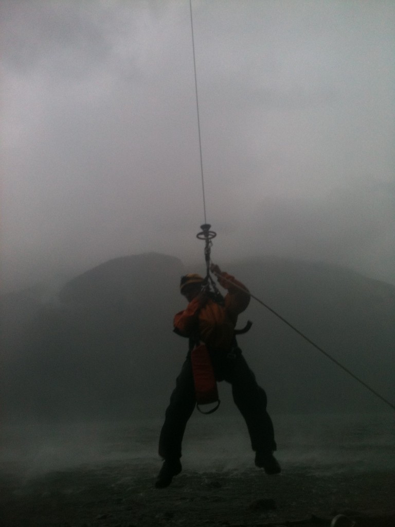
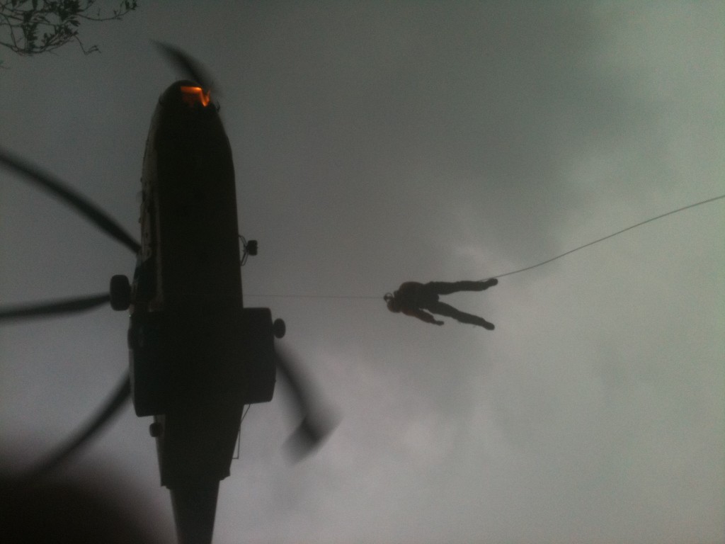
Because of the difficulty accessing the position, a decision was made to use HETS (Short Haul) to extract the subjects to the beach area. The subjects were unharmed, and very grateful. The rescue team was then extracted, and the search stood down.
The subjects had been stopped by high water in Disc Creek on Sunday afternoon. After attempting to cross the creek for many hours, they had to camp for the night. Sunday evening and Monday morning a large storm passed over the south coast of BC, bringing 50mm of rain. This made all of the creeks in the area swell even more, effectively cutting the subjects off. They activated the PLB near noon on Monday after many attempts to backtrack. They were spotted by the helicopter near 11am on Tuesday, and were extracted from the field by 13:10, and were with their families at the command centre by 13:50.
Analysis
Early in the search the reported PLB position was assumed to be more accurate than it actually was. As more positions were reported, it became apparent that it was not in fact as accurate as we had hoped. An analysis of the coordinates reported to us shows that they varied from the actual position by as little as 80m, and by as much as 1.2km. The average displacement was 700m, and the standard deviation was 495m.
The following map contains the reported PLB “fixes” and the actual position of the subjects
View Debeck Creek PLB in a larger map
Falling back on good search techniques in this situation was essential. With the weather making helicopter flight impossible it was vital to get ground teams moving through the dense bush as fast as possible because our previous experiences in this area had shown us that the rate of travel was very slow.
A break in the weather, and the fact that the subjects had a flare, made the discovery of their position, and subsequent rescue a simple task. The availability of the helicopter, and the HETS rescue technique vastly sped up the extraction. If the weather had not broken, ground team members would have had to rig a high line (Tyrolean) across one of the creeks, and brought the subjects out on foot. It is estimated that this would have taken at least another day.
Without knowing the reason for the PLB activation, SAR teams must proceed as if an injury has occurred, and make all attempts to find the subjects. Activation of most PLB models is not easily done, and the possibility of an accidental activation is extremely unlikely. The importance of the ground response on this task cannot be over stated, since early in the search it was impossible to fly to the reported location even for the highly capable Cormorant CH-149.
In this search, the terrain necessitated a multi-modal response via air, land and by boat. The RCMP Rigid Hull Inflatable (RIB) provided a valuable platform to relay radio communications down the lake from this remote valley. The boat also provided a safety system for the HETS rescue near the beach, as they had to fly over the lake briefly for the final approach.
Recommendations
All SAR teams receiving PLB reported coordinates should be sure to ascertain the “error level”, or how accurate the position is considered. If possible, attempt to discover the brand of PLB and whether it contains a GPS unit. Range finding hardware (similar to an avalanche transceiver) is available that can pick up the 406MHz signal from a hand held unit that can be carried by ground or air searchers, this can vastly narrow down the search area.
Backcountry users must realize that claims on the PLB’s ability to report your position are often not as accurate in real life situations. The accuracy of the GPS-enhanced models is at best +/-125m, under conditions where the GPS signal is strong, and the 406MHz signal can be transmitted reliably to the SARSAT GEOSAR system. Remember, you have in your hands a device that takes a signal from one satellite system, and transmits it to a second satellite system. It’s an amazing piece of technology, but it’s doing a lot of work. Conditions have to be good for this to function without some error.
Also remember that once the PLB is activated, SAR will be attempting to find you, and rescue you, but this takes time. In this case it took just over 24 hours from the time the PLB was activated until the subjects were extracted. Weather, terrain, and many other factors can effect the speed of the response.
Some advice when activating a PLB:
- Choose a spot with as clear a view of the sky as you can. The longer the satellite systems can “see” you, the better the fix will be
- An air search is almost certain. If possible choose a place with a clearing that you can be visible from the air.
- Try not to move once the PLB is activated. Some models do not update the GPS fix once it is obtained, and so will continue to report the previous position.
- DO NOT turn the device off. You may think you’re saving batteries, but you’re really interfering with how the device works. The fix gets better over time, and the 407 MHz signal is used for homing in on the location.
- Carry flares or other signalling devices. These reduce the time it takes an aircraft to pinpoint your position. Also, read my article on being found by a helicopter.
Note: Images in this article are property of members of Coquitlam SAR or Michael Buchko and are not covered under the Creative Commons license governing the rest of this site. Permission is required for re-use or re-distribution.
Excellent article. It would be interesting to test different PLB models to see how fast and how accurate their coordinates are for future SAR searches.
Interesting read Mike, even with all the gadgets we usually still must rely on experience, good instincts and common sense to accomplish these tasks. I have only one thing that I would like to mention. You talk about the importance of getting ground searchers moving as quickly as possible. I couldn't agree more, especially when we are facing the weather of that day. I think the most important thing to do is to "front load" every call with the most appropriate method available. The issue I have is when you talk about using 442 when the weather is too poor for a commercial operator. In this case the belief that 442 could fly when others can't, in my opinion slowed down the call. While the military has some advantages, doing a mountain rescue in poor weather is generally not one of them. The IFR capability they have doesn't give them a benefit in this case. Kelsey
Kelsey, you're absolutely right. I didn't mean to imply that the Cormorant was able to fly when you could not. In fact I was on the conference call and we made no such assumption, Ian Mac (former helicopter pilot) said clearly that 442 would not be able to reach the subject's location if you could not.
You're also right that 442 took longer to launch, and longer to reach our area, and this could have delayed the call. There may have been other issues, however.
For instance, I don't think there's an LZ near the beach that works at high tide. I don't know where the tide was at, but this may have been a consideration. 442 was able to winch our guys onto the beach.
In parallel to the air approach, we were launching the RCMP RIB, contacting Ridge Meadows SAR for their boat, and in the process of launching our own RIB. The original plan included the boat taking teams up the lake.
I'll follow up with the other managers on the task and see what the thinking was, and perhaps talk to you offline as well.
Great info Thank you
I personally own a Fastfind210 and after this rescue was a bit depressed to see how inaccurate the GPS signal actually is.
Then to see that local SAR's doesn't have the equipment to use the back up homing signal. Makes the manufactures so call sales pictches of fast find rescue a tad off the mark.
Thanks again for the info
Range finding hardware (similar to an avalanche transceiver) is available that can pick up the 406MHz signal from a hand held unit that can be carried by ground or air searchers, this can vastly narrow down the search area.
I want to be clear. Several teams, including mine, have the 121.5 radio direction finder. I do believe that the manufacturer's web sites tend to either overstate, or to describe the best case scenario for how their devices operate.
In this search, even if the device was completely accurate, we would not have been able to reach that position for 24 hours (when the weather changed).
If the subjects had no PLB, we would have been called 2 days later when they were overdue, and our search area would have been enormous. So the PLB did it's job, and the subjects were rescued.
Hello. A very interesting incident with, despite all the effort put in by the searchers / rescuers, a good outcome.
Like most other devices, there are PLBs and PLBs – in other words, some work better than others and newer models tend to have better GPS modules. I really can’t see the point of buying a PLB now that doesn’t have an integrated GNSS chip. Beacons tested by me (and used in anger over the last week or so) can, in good conditions, acquire GPS ‘lock’ and transmit the refined data-burs with embedded GPS-derived positiont within 52 seconds. The refined position accuracy at our latitudes (57 N) can fairly reliably said to be within 120 metres. If conditions don’t favour GPS reception, a coarse GPS position will often be produced – in broad terms, this can be said to be within either 2 or 15 nautical miles, dependant on the protocol used in coding the beacon.,
If GPS co-ordinates cannot be calculated, for whatever reason,the Doppler-derived alternative has to be used. This tends to be less accurate and can only be quoted, even with a solid set of bursts, to be within 5 nautical miles – even though it is often well within that. The Doppler and GPS positions are distinct from each other, so shouldn’t be mixed up.
As you say, the beacon should be placed out in a clear position and left there – don’t keep leaning over it to see if it’s working (smile). The antenna must be as vertical as possible. The Mission Control Centre should be able to tell you roughly how good or bad the each updated result is. Modern beacons freqiemtly update the GPS position and every time one of the six Low Earth-Orbiting satellites (LEOSAT) ‘passes’ over, an updated and (it is hoped) refining position will be received. The LEOSATs are at an altitude of between approximately 700 and 900 km. Additionally, geostationary satellites (GEOSATs), at an altitude of about 36,000 km, are dotted around above the Equator. Unlike that of the LEOSATs, the relationship between the GEOSAT and beacon will remain constant unless you move the beacon; if it doesn’t ‘see’ the GEOSAT, then it won’t unless you move it clear of the obstruction that’s blocking the signal – and that obstruction could easily be a mountain, especially in BC.
We had an incident last week when overseas visitors with a PLB became distressed/lost in cloud on a mountain and the mountain rescue team went straight to them – first data-burst contained the refined GPS position and the GEOSAT received / relayed that position that was on the MCC Operator’s monitor within 5 minutes.
That’s enough, except to say that they do work and The Medium Earth Orbiting system and the next generation beacons will be operational in a few years and they should be (even) better. . .
Thanks for the eye opening article explaining the “magic” behind the device. I always assumed from the information I had been given that PLBs always gave a reliable location fix (it’s the number one argument that PLB proponents make when they are attempting to get SPOT users to buy a PLB). I should have known that nothing is ever quite so simple. Do you know of other instances where PLB locations have not been completely accurate? And slightly related, do you know of any instance where a PLB signal failed to get through at all?
Yes, recently I talked to someone who works at JRCC (Canada’s Join Rescue Coordination Centre), the agency that receives all of the PLB/SPOT messages from the various downlink sites around the world.
PLB was originally designed for aircraft and marine use and was re-purposed for ground SAR. Also it didn’t used to have a a GPS (some still don’t). So the signal was triangulated to provide a location. The GPS signal is “carried” on the transmission and is truncated a little bit, so it loses some accuracy there. Also, when the PLB is triggered it often hasn’t been turned on for months or years and the first thing it has to do is “warm up” by downloading the ephemeris data which can take 20 minutes depending on the view of the sky and the weather.
Long story short, no location is ever without some error and uncertainty. The story I told to the JRCC staff member was completely understandable and he said it fit with all of the other activations he has handled.
The initial signal gives you a general location. You can expect it to stabilize, but since it was intended for aircraft to search with, you need to take that into account for a ground response.
Thanks, makes perfect sense.
Is there any advantage to a PLB that uses triangulation versus a GPS or is it simply the older and/or cheaper technology?
Honestly do not know if there is an advantage to using the older ones. I guess, as you pointed out it might be cheaper although price is a tricky thing. The GPS hardware is only a few cents.
Great article Micheal, very informative as always.
I hate to be pedantic, but since accurate information could save a life here goes.
Triangulation is never used to fix the position of a PLB, ELT or EPIRB. A position is computed from the doppler shift of the beacon transmitted signal as observed by the satellite. The technique used for 406 MHz units is the same as was used with 121.5 MHz but the 406 MHz devices have more stable frequency references which provides a smaller confidence interval. The technology can be confounded by environments that alter the phase of the signal, which are numerous. In this case all the positions were within 2 km of the actual beacon location. This is about the very best you can expect. I am surprised that JRCC was not providing confidence values for the fixes. When they don’t who ever is communicating with them should ask.
However, even when the confidence is high, the accuracy can turn out to be very poor. It is not possible to know the accuracy of the fixes until ground truth is established by finding the beacon. This is similar to assesing GPS accuracy. You can compute the dilution of position, and you can measure the amount of noise in a set of fixes. But unless you know what your actual position is from an independent survey you can not compute the accuracy of the fixes.
ELTs and PLBs both evolved from EPIRBs designed for marine use and are still burdened with the compromizes made years ago when 406 EPIRPs were designed. The main main one being the antenna. Polarity of transmit and receive antennas, with respect to each other is important. However with satellite systems maintaining common orientation is impossible, so circular polarization is usually used. PLBs, ELTs and EPIRBs all use vertically polarized whip antennas. This means that about half the transmit power of the beacon is lost to polarity mismatch. Unfortunately a circularly polarized 406 MHz antenna would not be very portable. The other issue is that a vertically polarized whip radiates most energy towards the horizon where it may be waisted against the mountainside. This is NOT a reason to ignore the advice to place the beacon with the antenna vertical however. Orienting the antenna other than vertically can result in even worse performance. Aircraft accidents often result in beacon antennas that are not vertical and this can cause problems detecting and locating the beacon.
Avalanche beacons operate on very different frequencies (457 kHz) than PLBs (406 MHz), a factor of nearly 1000. Searches using avalanche beacons would be conducted entirely within the near field. Searches for PLBs would be conducted entirely in the far field. Searchers should avoid asuming what works with one will be applicable to the other.
All this notwithstanding, if you are in trouble in the bush it is much better to have a PLB, than not. Searchers are much more likely to make a rescure, than a recovery, if they have data from a PLB, even if it is not as accurate as they expect. You have made this quite clear. All the devices you have discussed have their advantages and limitations. Not having any of them would be the biggest limitation.
Richard, comments like this one are the reason I write this blog. Every time I think I know everything I need to know, someone who knows more comes along and I learn more about it. Thanks so much for taking the time to write!
I think we may have met at SARScene a few years ago but my memory is not clear.
Re, direction finding. In the absence of a directional antenna connected to a purpose built radio finder, a responder with a handheld amateur radio capable of UHF or AM aircraft band, can use their radio and omni directional vertical antenna. Simple set the radio to the 406MHZ FM, or 121.5MHZ AM frequency and hold the radio vertical about 2″ in front of your chest. Use your body to shield or limit the antennas ability to pick up signals from behind you. Stand in one spot, and rotate your body, and based on how well the signals audio tone is heard, or on the measured signal strength you can start to hone in on a direction. As you get closer to the target it will get harder to differentiate the strongest signal, so you can use tricks such as tuning slightly off frequency ie 121.15 or 121.0 or hold the antenna in a non vertical polarization. It works surprisingly well.
Personal Locator Beacons (PLB) save lives. Over 50% of man overboard accidents (MOB) end in fatality. In industries where many crew or passengers have neither PLB’s nor Lifejackets, such as cruise ships, 86% of MOB’s end in fatality. Rapid alarm and location are key to survival. The PLB solutions use a combination of alarm and location technologies in a single, compact, and robust unit.