BC TRIM Maps are just PDF

Wow, there is a lot of misinformation about the new TRIM series maps from the BC Government out there!
Please note new information at the end of this article.
Here is a link to the announcement on the BC “Newsroom site”, and the source of the problem:
VICTORIA – Recreationalists and resource professionals looking for an easier way to explore B.C.’s wilderness can now leave their fold-out maps at home. GeoBC has created a series of free, high-resolution topographical maps specifically designed for viewing on mobile devices.
Readers of this blog know my position on this issue. Smartphones should not be used for backcountry navigation. They have terrible battery life, they are fragile and prone to damage, and the GPS is less accurate than other commercial backcountry GPS units.
In the opinion of this author, and of most other SAR teams, a phone should be carried, powered down, and used in an emergency to call for help. Backcountry navigation should be done using a waterproof, purpose built wilderness GPS receiver, a compass and a paper map.
In fact, this announcement seems to indicate that these maps are somehow a navigation “app” for your smart phone, and nothing could be further from the truth!
What about the maps?
The “TRIM” (Terrain Resource Information Management) series data set was originally generated in 1996 and has been in the process of being updated since. It consists of 1:20,000 scale topographic maps for the province of BC, and it represents the best complete public data set covering the entire province. The Federal government data, by comparison, is at 1:50,000.
The public has had access to this data set for several years through iMapBC, an online map viewer and printing tool. With it you could browse the TRIM dataset (and much more!) much the same way you pan and zoom through Google earth, select layers, and save and print maps.
In addition, GeoBC made the same dataset available through a WMS server, and they also made a KML overlay file that allows Google Earth to consume the data.
In addition, SAR groups have had access to both the underlying data set, and a set of pre-rendered GeoTIFF files that were obtained through a series of signed MOUs and a NIF grant. Every one of the 80 teams in BC has been using this data for about 4 years now, and some teams for longer.
So this is not new data, and the public having access is not new either.
So what is this announcement about?
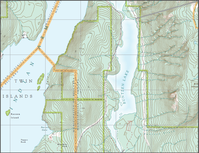
GeoBC has pre-rendered the data into UTM map sheets in PDF format.
That’s it!
What’s the fuss?
Well, there shouldn’t be a fuss, except for the possibility of this misinformation leading to the belief that you can just download these maps to your smart phone and somehow it will magically show you where you are.
These are PDF documents, plain and simple. There is no app. They are just maps.
However, they have some limitations. To be printed at the proper scale the maps are 44 inches by 28 inches. You can print a portion of the map on 8×10 or legal paper, but if you do the border of the map doesn’t print and the navigational grid labels won’t be on the map. If you do this be sure to transcribe the UTM and geographic grid (latitude and longitude) coordinates from the edge of the map onto your print out.

If you do put it on your smart phone or mobile device, you will either need a PDF viewer, or some other navigational software to read it. I have not been able to figure out if these maps adhere to the GeoPDF standard. If they do it is conceivable that some mapping software can use them “as is” to assist in navigation. If not, then some kind of georeferecing operation would have to take place first.
Also note that zooming in to an area on a 5 inch smart phone also clips out the labels on the grid lines, making it almost useless for navigation.
In summary, the announcement from the government is wrong; these are not special mobile maps. It’s also wrong that you can now leave your paper maps at home, these do not replace paper maps. The data, as released, does not constitute a navigation-ready solution for backcountry travel.
I would be happy to hear from any readers who know of any navigation software for any platform (Android, iOS, Windows) that can actually use these files.
Update
Based on the comments from kookjai (see below), I downloaded an Android app (there is an iOS one as well) that can read these files. It turns out that they are using the Geospatial PDF standard. This means that both the Android and iOS app mentioned can read and use these maps for navigation.
My objections to the announcement by the BC Government still stands however. While using your mobile device (smartphone, watch or tablet) as a navigation device might be OK if you have access to a reliable power source (4×4 vehicle, helicopter), this does not replace an actual map for backcountry hikers, mountaineers and skiers.

For IOS, Save the images to a dropbox folder, download and install avenza pdf map reader, link to dropbox and open up maps as desired. Will show your position on the map.
That’s a good tip on how to actually use the maps on a mobile device.
I just downloaded the Android version of their app and it works mostly (still in development).
It also answers a question I had; these do appear to be GeoPDF maps, since the application can read them and figure out the coordinates.
Thanks
If you want good scale 1:20 000 hillside shaded digital maps created from the BC Trim data, go to http://www.mapsdigital.com. These maps have the collars removed and can be easily tiled together . They are compatible with any program that can read a Geotiff or they are easily converted to be used with most gps mapping software. They are rasters not vectors.
umm your article is wrong and misleading…these maps are good to go for mobile users with the aveza pdf maps app. that’s all folks!
This was pointed out to me in 2013 by another user.
The update at the bottom of the article (see the text in orange at the top) indicates that the maps work with Avenza.