↓ Skip to Main Content
Oplopanax Horridus

Oplopanax Horridus

A veteran SAR volunteer's experiences in British Columbia

Follow Us on FacebookFollow Us on TwitterFollow Us on LinkedInFollow Us on YouTubeFollow Us on RSSFollow Us on StackOverflow

Main Navigation

  • About
    • About Me
    • Copyright
    • Privacy Policy
    • Commenting policy
    • Disclaimer
    • Why Oplopanax
  • Popular
    • On Blaming the Victim
    • How to Kill Yourself Snowshoeing
    • Smart Phones and Battery Life
    • Don’t use Smart Phones for Backcountry Navigation
    • PLBs from the Rescuer’s Perspective
    • Finding Someone from a Helicopter
    • On Coordinates
    • A Social Media Storm
  • Projects
    • TrueNorth Geospatial
    • Missing Poster Generator
    • YourLo.ca/tion
    • SAR Teams Map
    • Range Rings
  • SAR Links
    • BC SAR Teams
    • SAR Agencies
  • Media
  • Contact
Home › Posts tagged smart phone

Tag: smart phone

The future of public safety communications

By Michael Coyle Posted on 21/10/2014 Posted in Blog Entry 2 Comments Tagged with communications, emergency, emergency management, response, smart phone, technology
The future of public safety communications

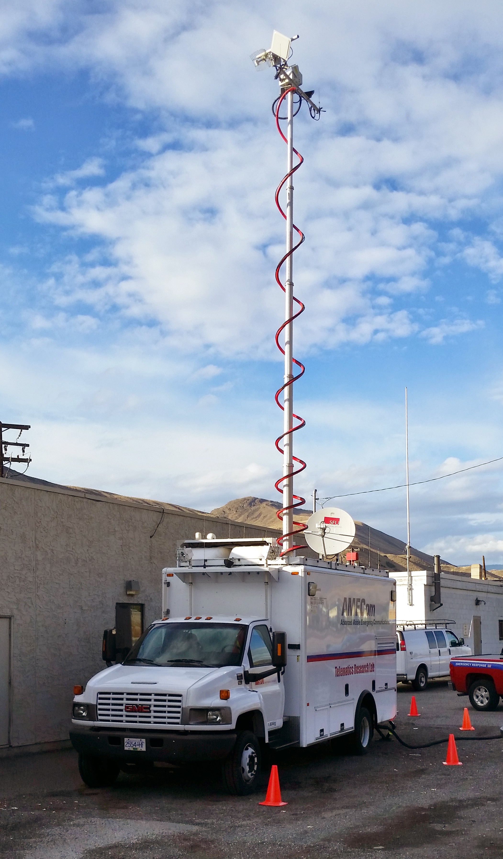
Last week I was in Ashcroft testing what will become the future of public safety communications networking; initial impressions of this emerging tech.

Locating lost people using Social Media

By Michael Coyle Posted on 11/08/2014 Posted in Blog Entry No Comments Tagged with communications, GPS, smart phone, SMS, SMSAR, social media, technology, YourLo.ca/tion
Locating lost people using Social Media

Assisting SAR teams to locate missing people using Social Media

Measuring GPS Precision

By Michael Coyle Posted on 13/03/2014 Posted in Blog Entry 1 Comment Tagged with GPS, smart phone, tech, technology
Measuring GPS Precision

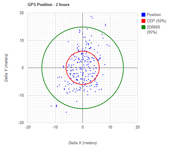
Following up on a series of posts on how to measure the error in a GPS, I’ve written a simple too that will let you calculate the precision of any GPS unit.

Smart Phone and GPS

By Michael Coyle Posted on 15/01/2014 Posted in Blog Entry No Comments Tagged with GPS, rescue, smart phone, tech
Smart Phone and GPS

Clarifications and reiterating smart phone GPS capabilities, PLBs, and how to automate the process of determining someone’s location.

BC TRIM Maps are just PDF

By Michael Coyle Posted on 20/06/2013 Posted in Blog Entry 5 Comments Tagged with data, map, smart phone
BC TRIM Maps are just PDF
Detail of map 092G036. You can't see the labels on the grid lines, so useless for navigation.

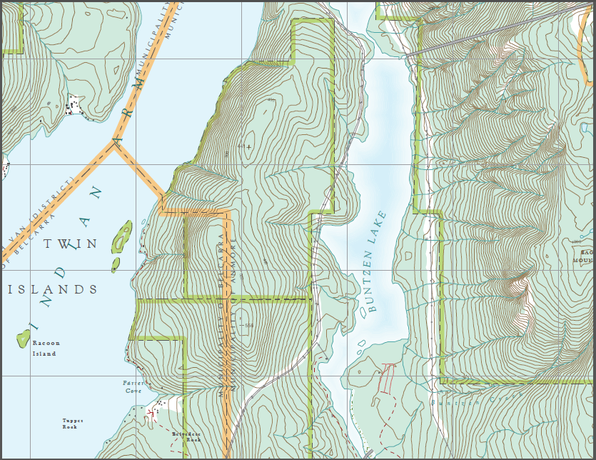
There’s a lot of misinformation about the newly downloadable BC TRIM maps in PDF formats. They are not “apps” and they are not a replacement for paper maps.

Calling for help early saves lives

By Michael Coyle Posted on 20/05/2013 Posted in Blog Entry 1 Comment Tagged with GPS, helicopter, rescue, smart phone
Calling for help early saves lives

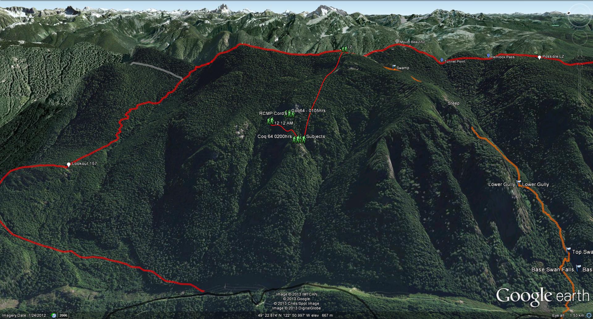
We used some high tech yesterday to locate the subjects of a search, but the real credit goes to calling for help early!

BCA Tracker 3 Avalanche Transceiver

By Michael Coyle Posted on 15/05/2013 Posted in Blog Entry, Photo No Comments Tagged with avalanche, BCA, smart phone, Tracker 3, transceiver
BCA Tracker 3 Avalanche Transceiver
Compared to a Tracker 2

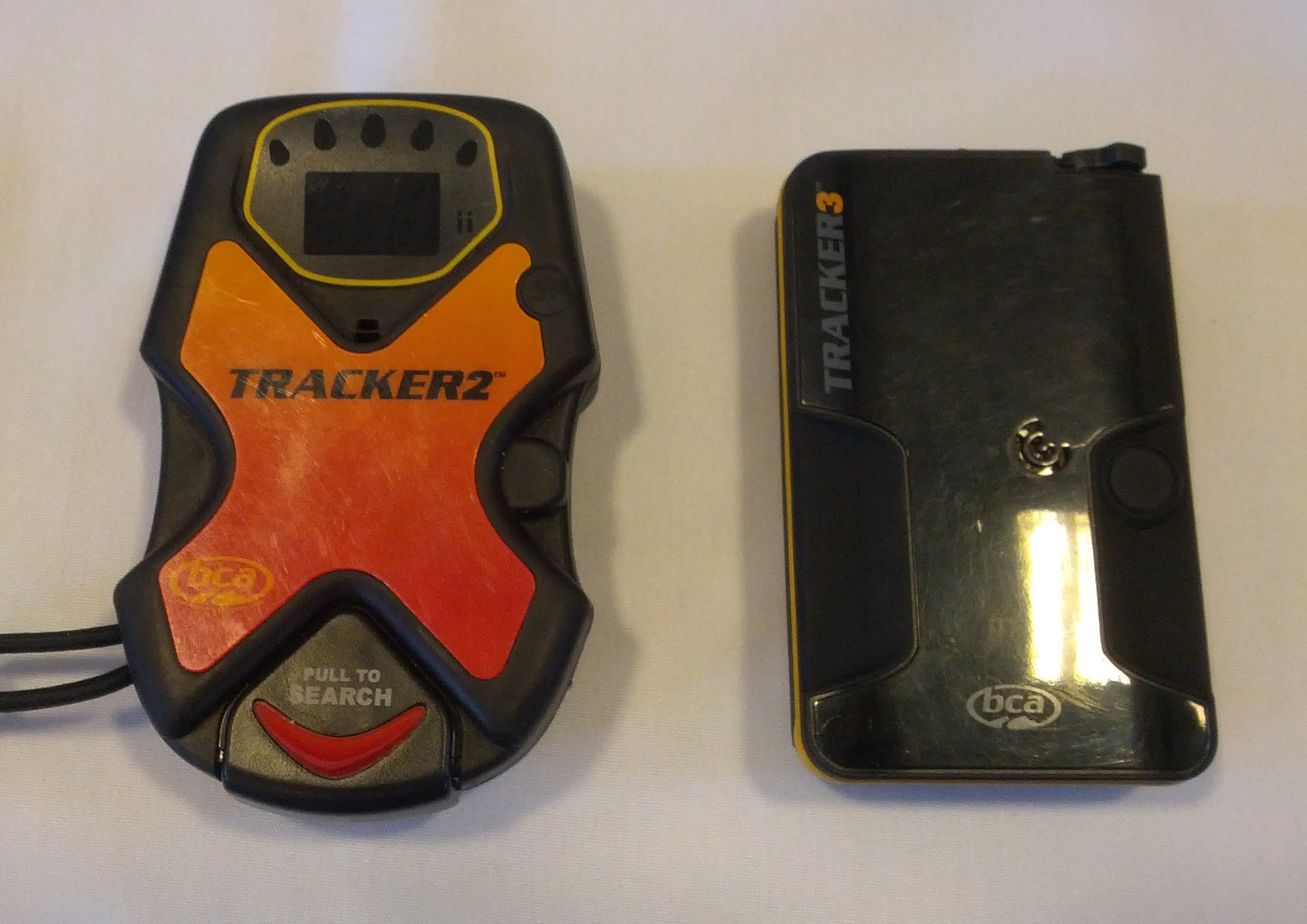
I got a first look at the BCA Tracker 3 Avalanche Beacon last week.

Locating lost people using smart phones

By Michael Coyle Posted on 05/03/2013 Posted in Blog Entry 8 Comments Tagged with emergency, GPS, map, project, rescue, smart phone, SMS, technology, YourLo.ca/tion
Locating lost people using smart phones

People don’t know how to make their smart phone show their location, so I created a service that lets SAR track a person’s location via their smart phone.

The SpareOne Emergency Cell Phone

By Michael Coyle Posted on 10/12/2012 Posted in Blog Entry 2 Comments Tagged with communications, emergency, gear, how-to, review, smart phone, technology
The SpareOne Emergency Cell Phone

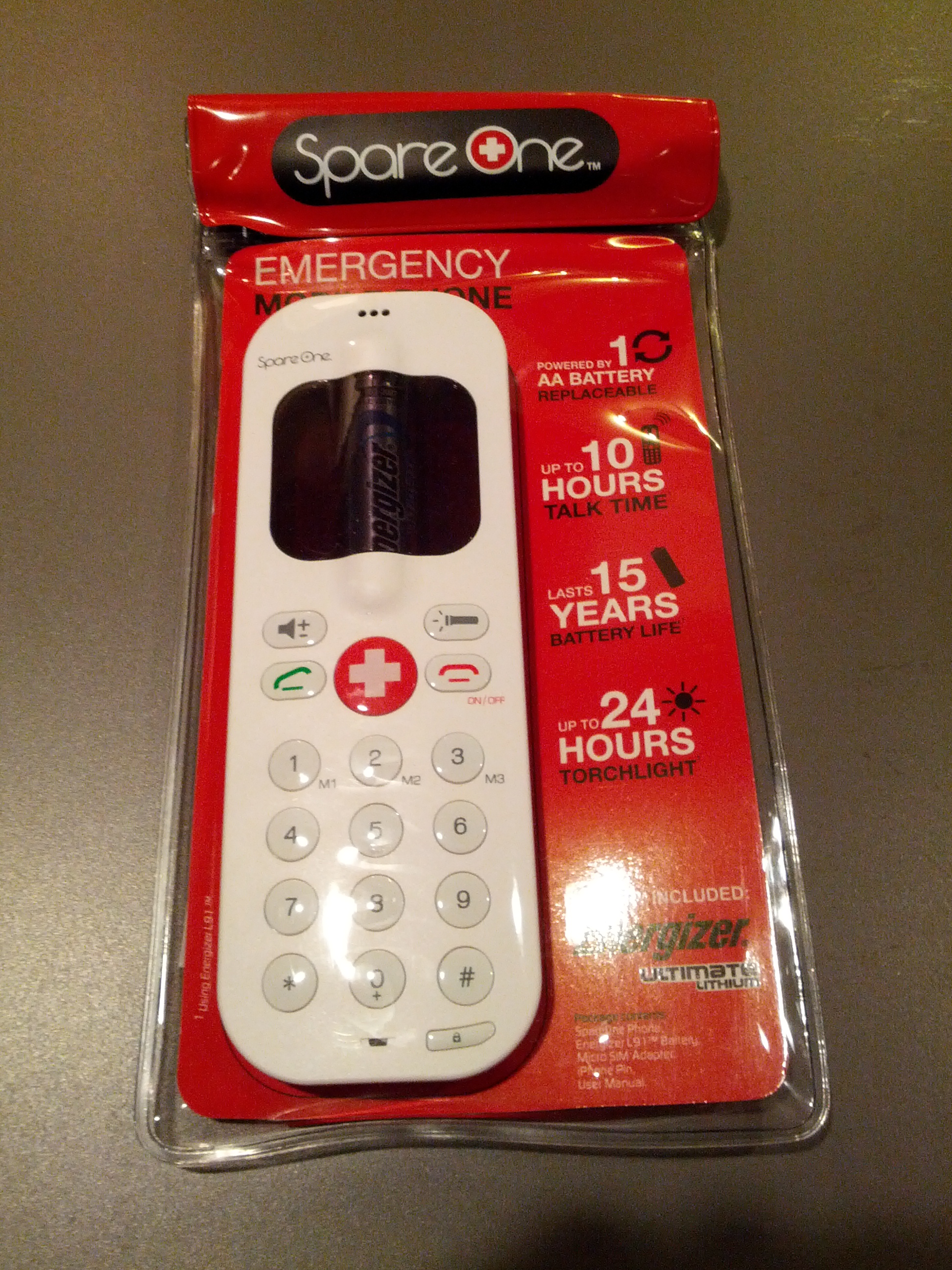
The SpareOne: a simple, voice-only 2G phone powered by 1 “AA” battery, but DOES NOT WORK on the Telus (3G) network. Otherwise perfect for emergencies

Stop with the Smart Phones already

By Michael Coyle Posted on 30/11/2012 Posted in Blog Entry No Comments Tagged with backcountry, communications, gear, GPS, opinion, rant, safety, smart phone, social media, technology

People are still under the impression a Smart Phone can replace a GPS in the wilderness, and they’re still wrong.

Posts navigation

1 2 Next
BlueToque Software
BlueToque Software
My software company
Software Design, Architecture and Consulting

TrueNorth Geospatial
The mapping software I designed for SAR
Mapping Software for Backcountry Professionals

YourLo.ca/tion
YourLo.ca/tion
Locate people using their SmartPhones

Buy a T-Shirt

Recent

  • Backcountry Safety is a Shared Responsibility
  • Are “selfies” hazardous?
  • “Dog Walker” Behaviour Profile
  • Reflections on 2017
  • Accidental Triggering of SPOT device

Tags

accident avalanche backcountry climbing communications death dementia emergency funding gear GPS grim helicopter HETS how-to InfoSAR Logan 2011 management map meta news numbers olympics opinion rant rescue review risk safety SAR SARDay search ski smart phone SMS snow snowshoe social media tech technology training Tyler Wright UAV video weather

Blogroll

  • AdventureSmart
  • Coquitlam SAR
  • North Shore Hikers
  • North Shore Outdoor
  • Outdoor Vancouver
  • Roland Web Memorial
  • SARBayes
  • TrueNorth Geospatial
  • Wayne Flann's Avalanche Blog

Older stuff

Recent

  • Backcountry Safety is a Shared Responsibility
  • Are “selfies” hazardous?
  • “Dog Walker” Behaviour Profile
  • Reflections on 2017
  • Accidental Triggering of SPOT device

Blogroll

  • AdventureSmart
  • Coquitlam SAR
  • North Shore Hikers
  • North Shore Outdoor
  • Outdoor Vancouver
  • Roland Web Memorial
  • SARBayes
  • TrueNorth Geospatial
  • Wayne Flann's Avalanche Blog

Projects

  • BlueToque Software
  • Missing Poster Generator
  • TrueNorth Geospatial
  • YourLo.ca/tion

Resource

  • AdventureSmart
  • Canadian Avalanche Association
  • Canadian Avalanche Centre
  • TrueNorth Geospatial

Projects

  • BlueToque Software Software architecture, design and build BlueToque Software Software architecture, design and build
  • Missing Poster Generator Easy generation, printing and sharing of missing posters Missing Poster Generator Easy generation, printing and sharing of missing posters
  • TrueNorth Geospatial Mapping software for backcountry professionals TrueNorth Geospatial Mapping software for backcountry professionals
  • YourLo.ca/tion A simple location finding, sharing and tracking service for SAR teams YourLo.ca/tion A simple location finding, sharing and tracking service for SAR teams
Creative Commons Licence
Oplopanax Horridus Copyright © 2013 by Michael Coyle
All content, except where otherwise noted, is licensed under a Creative Commons Attribution-NonCommercial-ShareAlike 2.5 Canada License.
Read about what that means, and contact the author for commercial licenses if necessary.

Footer Menu

  • Copyright
  • Disclaimer
  • Privacy Policy
  • Why Oplopanax
© 2023 © 2023 Oplopanax Horridus | Powered by Responsive Theme