↓ Skip to Main Content
Oplopanax Horridus

Oplopanax Horridus

A veteran SAR volunteer's experiences in British Columbia

Follow Us on FacebookFollow Us on TwitterFollow Us on LinkedInFollow Us on YouTubeFollow Us on RSSFollow Us on StackOverflow

Main Navigation

  • About
    • About Me
    • Copyright
    • Privacy Policy
    • Commenting policy
    • Disclaimer
    • Why Oplopanax
  • Popular
    • On Blaming the Victim
    • How to Kill Yourself Snowshoeing
    • Smart Phones and Battery Life
    • Don’t use Smart Phones for Backcountry Navigation
    • PLBs from the Rescuer’s Perspective
    • Finding Someone from a Helicopter
    • On Coordinates
    • A Social Media Storm
  • Projects
    • TrueNorth Geospatial
    • Missing Poster Generator
    • YourLo.ca/tion
    • SAR Teams Map
    • Range Rings
  • SAR Links
    • BC SAR Teams
    • SAR Agencies
  • Media
  • Contact
Home › Posts tagged software

Tag: software

The Missing Poster

By Michael Coyle Posted on 15/08/2012 Posted in Blog Entry 1 Comment Tagged with image, management, missing, photo, poster, search, software
The Missing Poster
Landscape output on Letter sized paper

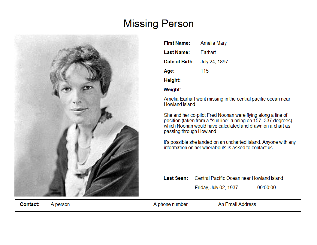
It’s not easy making poster for a missing person unless you’ve done some preparation. Two methods are presented for making the missing poster.

A different kind of emergency

By Michael Coyle Posted on 02/08/2010 Posted in Blog Entry No Comments Tagged with emergency, software, technology

I’m used to the pager going off in the middle of the night, but believe it or not I have had “emergencies” in my other line of work (software engineering) as well. One such happened last Wednesday. In my day …

A different kind of emergency Read more »

Excercise SILVER

By Michael Coyle Posted on 13/02/2009 Posted in Blog Entry No Comments Tagged with management, map, scenario, software, training

An Earthquake near Tsawwassen, a structure fire on Hamilton Street, a gas leak at Robson and Cambie, and a dirty bomb in Agasiz. Just another day in Excercise Silver. Silver, the second in the series of preperatory emergency excercises leading …

Excercise SILVER Read more »

BlueToque Software
BlueToque Software
My software company
Software Design, Architecture and Consulting

TrueNorth Geospatial
The mapping software I designed for SAR
Mapping Software for Backcountry Professionals

YourLo.ca/tion
YourLo.ca/tion
Locate people using their SmartPhones

Buy a T-Shirt

Recent

  • Backcountry Safety is a Shared Responsibility
  • Are “selfies” hazardous?
  • “Dog Walker” Behaviour Profile
  • Reflections on 2017
  • Accidental Triggering of SPOT device

Tags

accident avalanche backcountry climbing communications death dementia emergency funding gear GPS grim helicopter HETS how-to InfoSAR Logan 2011 management map meta news numbers olympics opinion rant rescue review risk safety SAR SARDay search ski smart phone SMS snow snowshoe social media tech technology training Tyler Wright UAV video weather

Blogroll

  • AdventureSmart
  • Coquitlam SAR
  • North Shore Hikers
  • North Shore Outdoor
  • Outdoor Vancouver
  • Roland Web Memorial
  • SARBayes
  • TrueNorth Geospatial
  • Wayne Flann's Avalanche Blog

Older stuff

Recent

  • Backcountry Safety is a Shared Responsibility
  • Are “selfies” hazardous?
  • “Dog Walker” Behaviour Profile
  • Reflections on 2017
  • Accidental Triggering of SPOT device

Blogroll

  • AdventureSmart
  • Coquitlam SAR
  • North Shore Hikers
  • North Shore Outdoor
  • Outdoor Vancouver
  • Roland Web Memorial
  • SARBayes
  • TrueNorth Geospatial
  • Wayne Flann's Avalanche Blog

Projects

  • BlueToque Software
  • Missing Poster Generator
  • TrueNorth Geospatial
  • YourLo.ca/tion

Resource

  • AdventureSmart
  • Canadian Avalanche Association
  • Canadian Avalanche Centre
  • TrueNorth Geospatial

Projects

  • BlueToque Software Software architecture, design and build BlueToque Software Software architecture, design and build
  • Missing Poster Generator Easy generation, printing and sharing of missing posters Missing Poster Generator Easy generation, printing and sharing of missing posters
  • TrueNorth Geospatial Mapping software for backcountry professionals TrueNorth Geospatial Mapping software for backcountry professionals
  • YourLo.ca/tion A simple location finding, sharing and tracking service for SAR teams YourLo.ca/tion A simple location finding, sharing and tracking service for SAR teams
Creative Commons Licence
Oplopanax Horridus Copyright © 2013 by Michael Coyle
All content, except where otherwise noted, is licensed under a Creative Commons Attribution-NonCommercial-ShareAlike 2.5 Canada License.
Read about what that means, and contact the author for commercial licenses if necessary.

Footer Menu

  • Copyright
  • Disclaimer
  • Privacy Policy
  • Why Oplopanax
© 2023 © 2023 Oplopanax Horridus | Powered by Responsive Theme