↓ Skip to Main Content
Oplopanax Horridus

Oplopanax Horridus

A veteran SAR volunteer's experiences in British Columbia

Follow Us on FacebookFollow Us on TwitterFollow Us on LinkedInFollow Us on YouTubeFollow Us on RSSFollow Us on StackOverflow

Main Navigation

  • About
    • About Me
    • Copyright
    • Privacy Policy
    • Commenting policy
    • Disclaimer
    • Why Oplopanax
  • Popular
    • On Blaming the Victim
    • How to Kill Yourself Snowshoeing
    • Smart Phones and Battery Life
    • Don’t use Smart Phones for Backcountry Navigation
    • PLBs from the Rescuer’s Perspective
    • Finding Someone from a Helicopter
    • On Coordinates
    • A Social Media Storm
  • Projects
    • TrueNorth Geospatial
    • Missing Poster Generator
    • YourLo.ca/tion
    • SAR Teams Map
    • Range Rings
  • SAR Links
    • BC SAR Teams
    • SAR Agencies
  • Media
  • Contact
Home › Posts tagged UAV

Tag: UAV

UAV Exemption myths

By Michael Coyle Posted on 18/05/2016 Posted in Blog Entry, Short Posts 1 Comment Tagged with technology, UAV
UAV Exemption myths

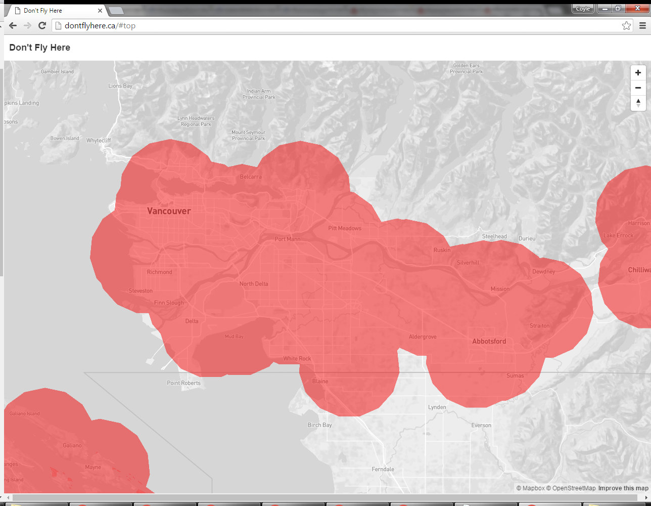
Where you can and can’t fly your UAV under the Transport Canada sub-2kg exemption for commercial use.

Update on UAV use for SAR in British Columbia

By Michael Coyle Posted on 07/01/2016 Posted in Blog Entry 1 Comment Tagged with technology, UAV
Update on UAV use for SAR in British Columbia
Not a UAV, right Peter?

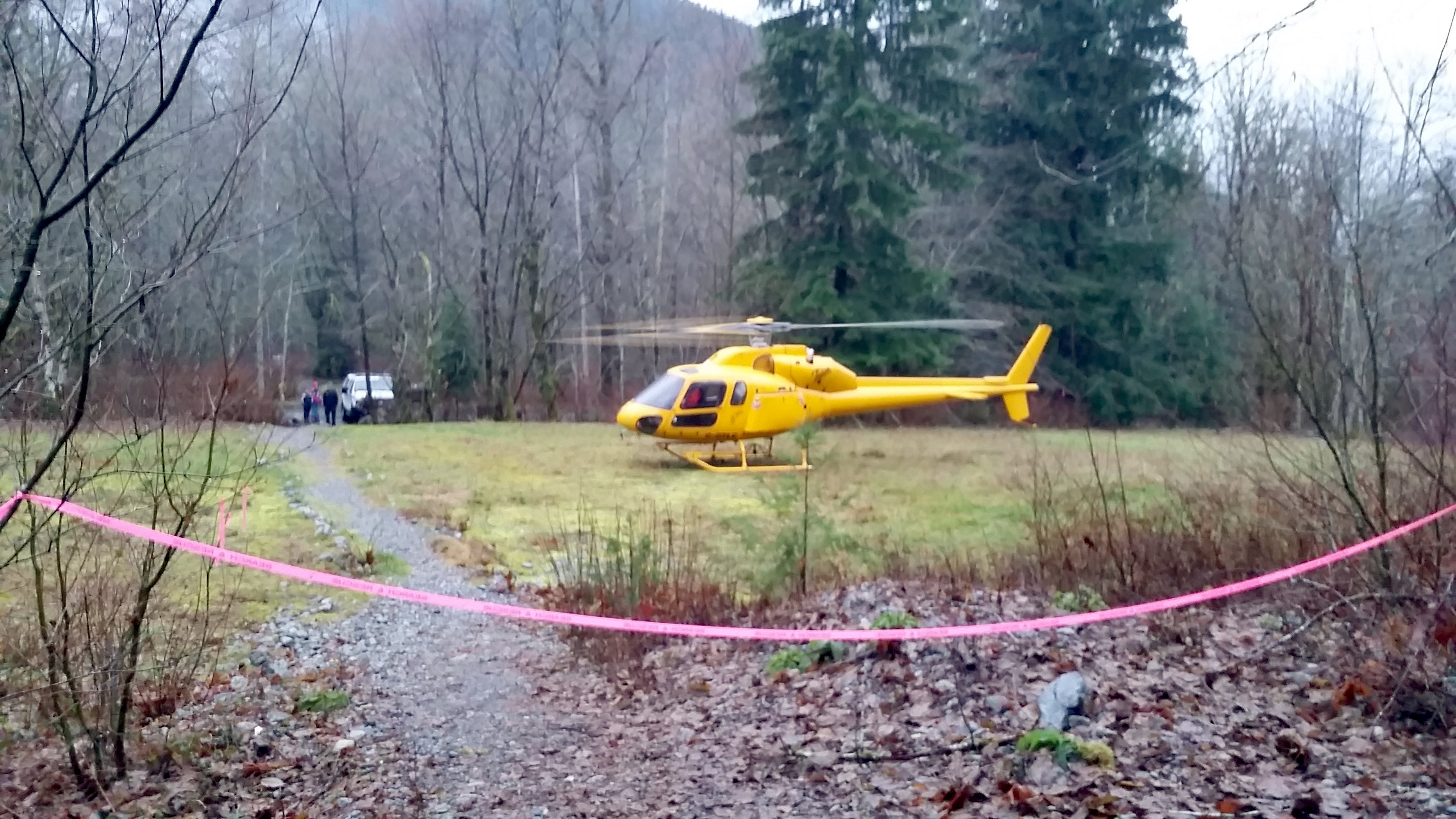
The following clarification on the use of UAVs was issued by Emergency Management BC a few weeks ago; it has important implications for SAR teams considering using UAVs. This is a significant development on project I’ve been working on for the past few …

Update on UAV use for SAR in British Columbia Read more »

UAV use cases for SAR

By Michael Coyle Posted on 27/01/2015 Posted in Blog Entry 5 Comments Tagged with SAR, tech, technology, UAV
UAV use cases for SAR
a UAV from Kaizen Kinetics Inc.

Some musings on use cases for UAVs in Search and Rescue, the result of a few years thinking about the topic.

UAV Operations for Canadian SAR Teams

By Michael Coyle Posted on 16/07/2014 Posted in Blog Entry No Comments Tagged with Regulations, SAR, UAV
UAV Operations for Canadian SAR Teams

UAV operations for SAR teams in Canada; bottom line is amateur operators cannot fly for Search and Rescue

Uses for UAVs in SAR

By Michael Coyle Posted on 10/07/2014 Posted in Blog Entry 3 Comments Tagged with communications, tech, technology, UAV
Uses for UAVs in SAR

Some proposed uses for UAVs in SAR based on a year of consulting experts, feel free to contribute to this conversation.

UAV Regulations

By Michael Coyle Posted on 12/05/2014 Posted in Blog Entry 1 Comment Tagged with regulation, UAV
UAV Regulations
QuadCopter UAV

UAV regulations that ban their use are worse than nothing because people are going to fly them anyway. Common sense regulations need to be put in place.

Avalanche Journal Article on UAVs in SAR

By Michael Coyle Posted on 01/03/2014 Posted in Short Posts 2 Comments Tagged with avalanche, journal, UAV

A link to my article in the Canadian Avalanche Association’s publication, The Avalanche Journal

SAR in BC for UAV operators

By Michael Coyle Posted on 13/01/2014 Posted in Blog Entry 1 Comment Tagged with emergency management, ICS, incident command system, management, SAR, technology, UAV
SAR in BC for UAV operators

Some resources on how Search and Rescue works in British Columbia for UAV operators.

Unmanned Aerial Vehicles: the basics

By Michael Coyle Posted on 08/01/2014 Posted in Blog Entry No Comments Tagged with SAR, technology, UAV, video
Unmanned Aerial Vehicles: the basics
QuadCopter UAV

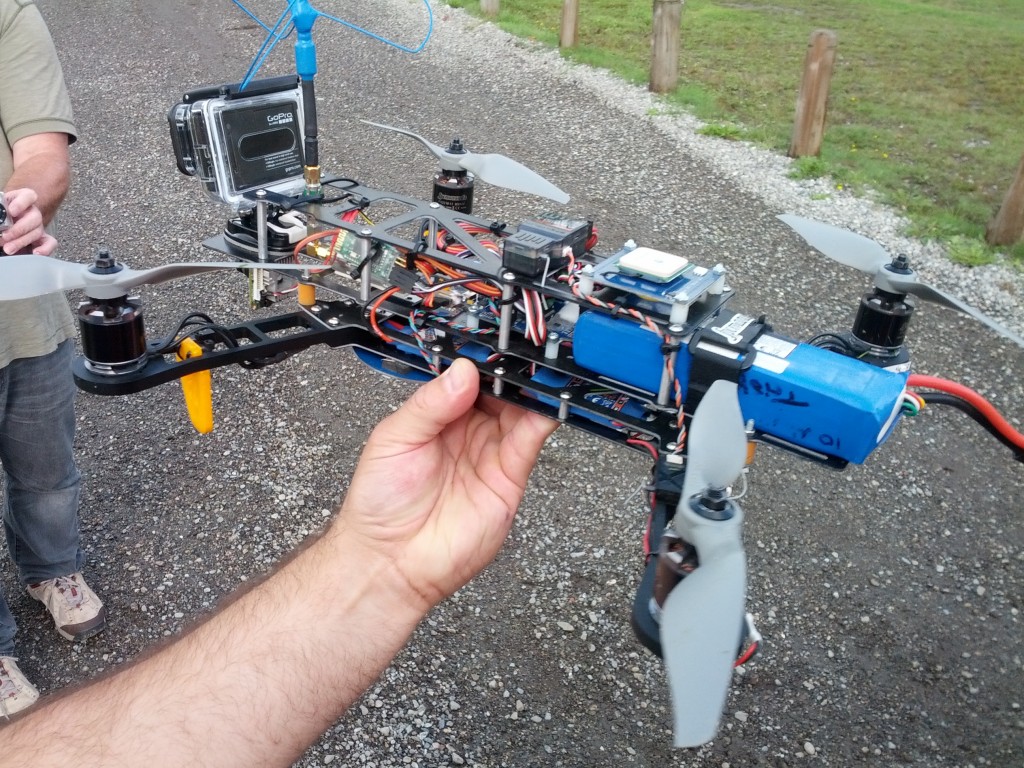
Some basic facts about the operational use of Unmanned Aerial Vehicles for Search and Rescue in Canada, and in BC

Unmanned Systems Canada

By Michael Coyle Posted on 14/11/2013 Posted in Blog Entry, Short Posts 1 Comment Tagged with SAR, technology, UAV
Unmanned Systems Canada
QuadCopter UAV

I presented at the Unmanned Systems Canada conference in Vancouver on the operational use of UAVs for Search and Rescue.

BlueToque Software
BlueToque Software
My software company
Software Design, Architecture and Consulting

TrueNorth Geospatial
The mapping software I designed for SAR
Mapping Software for Backcountry Professionals

YourLo.ca/tion
YourLo.ca/tion
Locate people using their SmartPhones

Buy a T-Shirt

Recent

  • Backcountry Safety is a Shared Responsibility
  • Are “selfies” hazardous?
  • “Dog Walker” Behaviour Profile
  • Reflections on 2017
  • Accidental Triggering of SPOT device

Tags

accident avalanche backcountry climbing communications death dementia emergency funding gear GPS grim helicopter HETS how-to InfoSAR Logan 2011 management map meta news numbers olympics opinion rant rescue review risk safety SAR SARDay search ski smart phone SMS snow snowshoe social media tech technology training Tyler Wright UAV video weather

Blogroll

  • AdventureSmart
  • Coquitlam SAR
  • North Shore Hikers
  • North Shore Outdoor
  • Outdoor Vancouver
  • Roland Web Memorial
  • SARBayes
  • TrueNorth Geospatial
  • Wayne Flann's Avalanche Blog

Older stuff

Recent

  • Backcountry Safety is a Shared Responsibility
  • Are “selfies” hazardous?
  • “Dog Walker” Behaviour Profile
  • Reflections on 2017
  • Accidental Triggering of SPOT device

Blogroll

  • AdventureSmart
  • Coquitlam SAR
  • North Shore Hikers
  • North Shore Outdoor
  • Outdoor Vancouver
  • Roland Web Memorial
  • SARBayes
  • TrueNorth Geospatial
  • Wayne Flann's Avalanche Blog

Projects

  • BlueToque Software
  • Missing Poster Generator
  • TrueNorth Geospatial
  • YourLo.ca/tion

Resource

  • AdventureSmart
  • Canadian Avalanche Association
  • Canadian Avalanche Centre
  • TrueNorth Geospatial

Projects

  • BlueToque Software Software architecture, design and build BlueToque Software Software architecture, design and build
  • Missing Poster Generator Easy generation, printing and sharing of missing posters Missing Poster Generator Easy generation, printing and sharing of missing posters
  • TrueNorth Geospatial Mapping software for backcountry professionals TrueNorth Geospatial Mapping software for backcountry professionals
  • YourLo.ca/tion A simple location finding, sharing and tracking service for SAR teams YourLo.ca/tion A simple location finding, sharing and tracking service for SAR teams
Creative Commons Licence
Oplopanax Horridus Copyright © 2013 by Michael Coyle
All content, except where otherwise noted, is licensed under a Creative Commons Attribution-NonCommercial-ShareAlike 2.5 Canada License.
Read about what that means, and contact the author for commercial licenses if necessary.

Footer Menu

  • Copyright
  • Disclaimer
  • Privacy Policy
  • Why Oplopanax
© 2023 © 2023 Oplopanax Horridus | Powered by Responsive Theme