↓ Skip to Main Content
Oplopanax Horridus

Oplopanax Horridus

A veteran SAR volunteer's experiences in British Columbia

Follow Us on FacebookFollow Us on TwitterFollow Us on LinkedInFollow Us on YouTubeFollow Us on RSSFollow Us on StackOverflow

Main Navigation

  • About
    • About Me
    • Copyright
    • Privacy Policy
    • Commenting policy
    • Disclaimer
    • Why Oplopanax
  • Popular
    • On Blaming the Victim
    • How to Kill Yourself Snowshoeing
    • Smart Phones and Battery Life
    • Don’t use Smart Phones for Backcountry Navigation
    • PLBs from the Rescuer’s Perspective
    • Finding Someone from a Helicopter
    • On Coordinates
    • A Social Media Storm
  • Projects
    • TrueNorth Geospatial
    • Missing Poster Generator
    • YourLo.ca/tion
    • SAR Teams Map
    • Range Rings
  • SAR Links
    • BC SAR Teams
    • SAR Agencies
  • Media
  • Contact
Home › Posts tagged InfoSAR › Page 2

Tag: InfoSAR

Map of SAR Incidents in BC 2011

By Michael Coyle Posted on 25/01/2012 Posted in Blog Entry No Comments Tagged with Incidents, InfoSAR, map, numbers, SAR
Map of SAR Incidents in BC 2011
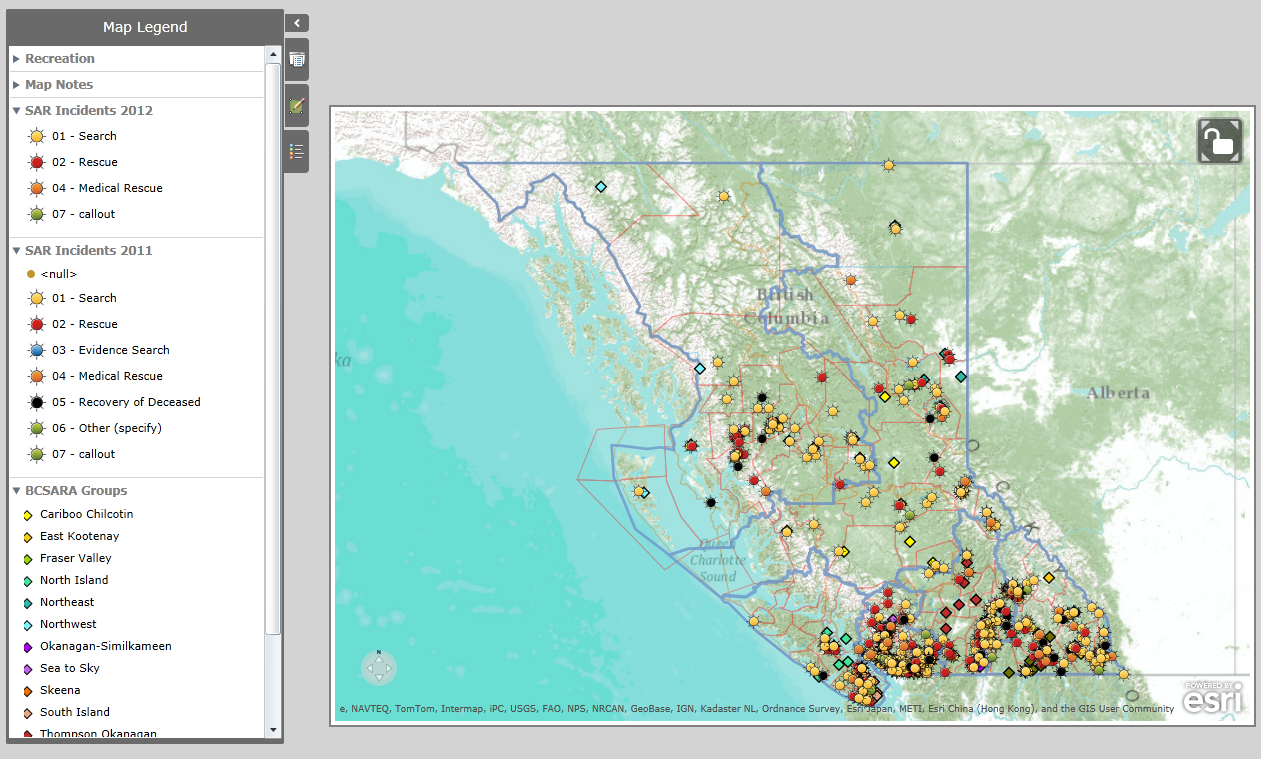
Map of BC SAR Teams and Incidents from 2011 /2012

A map plotting the location of all of the SAR incidents in BC for 2011 and 2012, including the location of each team in BC.

Archived Avalanche Bulletins

By Michael Coyle Posted on 02/01/2012 Posted in Blog Entry No Comments Tagged with avalanche, InfoSAR, snow
Archived Avalanche Bulletins
Electron Microscope image of a snowflake

How to retrieve archived avalanche bulletins from the Canadian Avalanche Association

Accidents in Incidents: A review of SAR-related injuries

By Michael Coyle Posted on 07/01/2011 Posted in Blog Entry 2 Comments Tagged with accident, InfoSAR, SAR
Accidents in Incidents: A review of SAR-related injuries

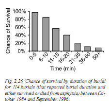
A review of the review of SAR related incidents.

Frequency of SAR Incidents

By Michael Coyle Posted on 19/12/2010 Posted in Blog Entry, Essay 3 Comments Tagged with InfoSAR, numbers, SAR, statistics, technology
Frequency of SAR Incidents
SAR Incidents by Week and Type (2003 to 2010)

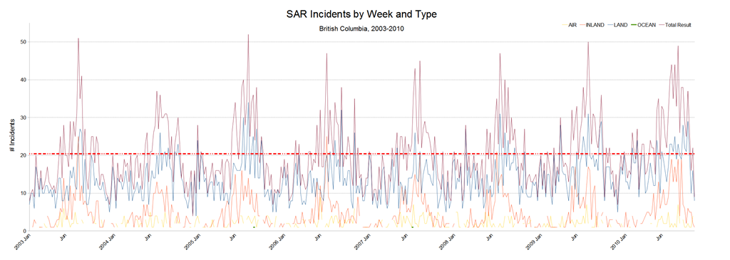
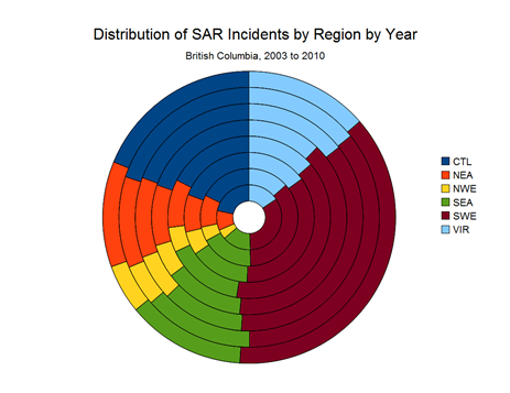
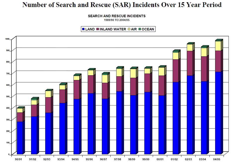
I analysed some numbers on SAR Incidents in British Columbia and made a few graphs showing how the frequency of incidents changes with the season.

Distribution of SAR Incidents in BC

By Michael Coyle Posted on 17/12/2010 Posted in Blog Entry, Essay 3 Comments Tagged with InfoSAR, numbers, SAR
Distribution of SAR Incidents in BC

The distribution of SAR tasks in British Columbia

Non-Avalanche Related Snow Immersion Death

By Michael Coyle Posted on 09/12/2010 Posted in Blog Entry No Comments Tagged with death, InfoSAR, rescue, safety, SAR, ski, snow
Non-Avalanche Related Snow Immersion Death

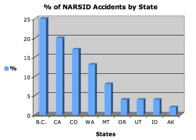
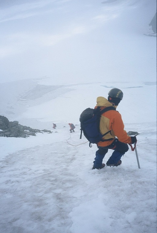
I was reading a local hiking/mountaineering forum recently when I came across this post detailing a very scary incident that happened to a skier at a local resort. And then I learned a new acronym: NARSID. Now I have never …

Non-Avalanche Related Snow Immersion Death Read more »

SAR Numbers from other Provinces

By Michael Coyle Posted on 08/12/2010 Posted in Blog Entry, Essay 2 Comments Tagged with InfoSAR, numbers, SAR
SAR Numbers from other Provinces
Flying over Whistler Village in 2008

Comparing SAR incident volumes in BC to those in other provinces. BC has more than the rest of Canada combined

How to NOT kill Yourself Snowshoeing

By Michael Coyle Posted on 29/11/2010 Posted in Blog Entry 11 Comments Tagged with accident, InfoSAR, numbers, safety, SAR, ski, snow, snowshoe, weather
How to NOT kill Yourself Snowshoeing
Descending Mount Matier

Some advice on what to do when everything goes to hell.

The (textual) shape of SAR in BC

By Michael Coyle Posted on 27/11/2010 Posted in Blog Entry 1 Comment Tagged with InfoSAR, numbers, SAR
The (textual) shape of SAR in BC

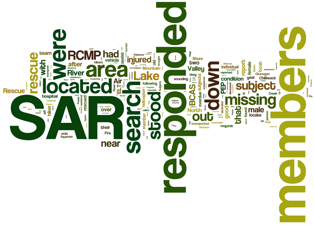
A word cloud generated from the BC Search and Rescue Incident Summaries shows us how we describe search and rescue in BC

On Avalanche accidents in BC

By Michael Coyle Posted on 24/11/2010 Posted in Blog Entry No Comments Tagged with avalanche, InfoSAR, safety, SAR, snow
On Avalanche accidents in BC

The survivability for avalanche accidents is low in BC.

Posts navigation

Previous 1 2 3 Next
BlueToque Software
BlueToque Software
My software company
Software Design, Architecture and Consulting

TrueNorth Geospatial
The mapping software I designed for SAR
Mapping Software for Backcountry Professionals

YourLo.ca/tion
YourLo.ca/tion
Locate people using their SmartPhones

Buy a T-Shirt

Recent

  • Backcountry Safety is a Shared Responsibility
  • Are “selfies” hazardous?
  • “Dog Walker” Behaviour Profile
  • Reflections on 2017
  • Accidental Triggering of SPOT device

Tags

accident avalanche backcountry climbing communications death dementia emergency funding gear GPS grim helicopter HETS how-to InfoSAR Logan 2011 management map meta news numbers olympics opinion rant rescue review risk safety SAR SARDay search ski smart phone SMS snow snowshoe social media tech technology training Tyler Wright UAV video weather

Blogroll

  • AdventureSmart
  • Coquitlam SAR
  • North Shore Hikers
  • North Shore Outdoor
  • Outdoor Vancouver
  • Roland Web Memorial
  • SARBayes
  • TrueNorth Geospatial
  • Wayne Flann's Avalanche Blog

Older stuff

Recent

  • Backcountry Safety is a Shared Responsibility
  • Are “selfies” hazardous?
  • “Dog Walker” Behaviour Profile
  • Reflections on 2017
  • Accidental Triggering of SPOT device

Blogroll

  • AdventureSmart
  • Coquitlam SAR
  • North Shore Hikers
  • North Shore Outdoor
  • Outdoor Vancouver
  • Roland Web Memorial
  • SARBayes
  • TrueNorth Geospatial
  • Wayne Flann's Avalanche Blog

Projects

  • BlueToque Software
  • Missing Poster Generator
  • TrueNorth Geospatial
  • YourLo.ca/tion

Resource

  • AdventureSmart
  • Canadian Avalanche Association
  • Canadian Avalanche Centre
  • TrueNorth Geospatial

Projects

  • BlueToque Software Software architecture, design and build BlueToque Software Software architecture, design and build
  • Missing Poster Generator Easy generation, printing and sharing of missing posters Missing Poster Generator Easy generation, printing and sharing of missing posters
  • TrueNorth Geospatial Mapping software for backcountry professionals TrueNorth Geospatial Mapping software for backcountry professionals
  • YourLo.ca/tion A simple location finding, sharing and tracking service for SAR teams YourLo.ca/tion A simple location finding, sharing and tracking service for SAR teams
Creative Commons Licence
Oplopanax Horridus Copyright © 2013 by Michael Coyle
All content, except where otherwise noted, is licensed under a Creative Commons Attribution-NonCommercial-ShareAlike 2.5 Canada License.
Read about what that means, and contact the author for commercial licenses if necessary.

Footer Menu

  • Copyright
  • Disclaimer
  • Privacy Policy
  • Why Oplopanax
© 2023 © 2023 Oplopanax Horridus | Powered by Responsive Theme