Smart Phone and GPS

 I noted that there was some chatter recently on how cell phone GPS units work, and some misinformation that deserves clarification.
First I would like to point out that the most probable place where an error in a GPS location happens is when one person reads the location out to another over the phone or a radio. There’s something about the transmission of numbers over the air; I’ve personally witnessed several instances where the reader misstates, or the recorder writes down the wrong numbers. This issue becomes more prevalent when one of the party in the communications link is scared, cold, and inexperienced with GPS coordinates.
Modern smart phones have a GPS receiver built in. They also use other methods to determine their location, decreasing in accuracy. These are:
- rough “network based” location that depends on triangulation from cell tower locations,
- Android phones can tell you where you are based on the location of a wireless access point.
Smart phones use the rough location to speed up the calculations of the GPS-assisted (accurate) location.
The GPS works whether you are connected to the internet or not.
When out of range (no signal) GPS based location is slower, but not less accurate.
However, your “apps” (mapping software, trail guides, etc) may not work when they do not have a data signal. This is important especially if you’re using the phone for navigation. I do not recommend you ever use a cell phone for your primary navigation device, and have written extensively on this topic.
However, if you do use navigation software, make sure it does three things
- Works offline: this can be described as “caching” the maps so they are available when the phone has no data connection
- Displays your coordinates: if SAR needs to know where you are, we use your coordinates. If you can;t read these off the phone to us, we’re not sure how to find you.
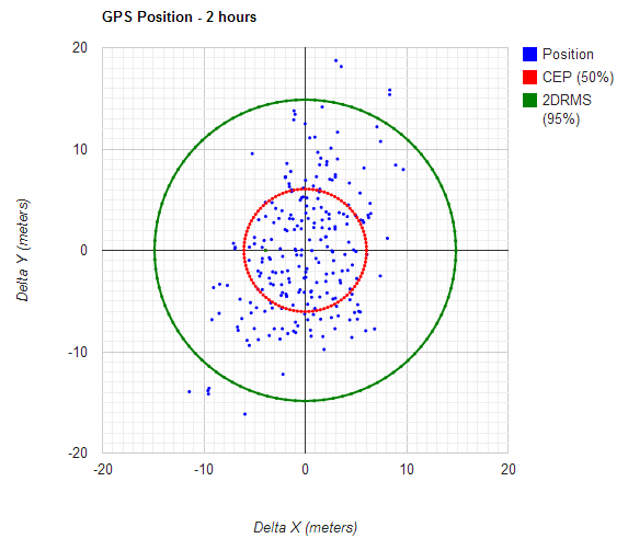
- Displays the error: all GPS devices have a certain error in their calculations and smart phones have roughly double the error of a wilderness GPS unit. Being able to send the estimate of the error in your location can give the SAR team some confidence in the position you are reporting.
Beacons
Personal Locator Beacons (PLB) and Satellite Enhanced Messaging Devices (SEND) such as SPOT and Delorme, also use GPS. Unlike a wilderness GPS, they may require a lot of time to “warm up” and attain a position lock. They cannot use the network like a smart phone to assist in the calculations, and often have to start “cold”.
They do not report the accuracy of the signal! As documented in my article from 2011, the error in the position reported by these devices can by much bigger than that reported by a smart phone, and can catch SAR agencies by surprise.
Planning the rescue around the initial reported position is not a good idea; with a PLB make sure to wait for updates in the location that get more accurate as the device “homes in”, and with SEND devices make sure to plan to search an area around the initial position.
Automating the Process
 Last summer I developed a service that automates the process of making contact with a missing person, determining their location, estimating the error, and communicating it back to the SAR team. This service is free for all SAR groups to use and I will also offer my services to help you integrate it into what ever your current processes are.
The YourLo.ca/tion service is currently being tested and used on live searches all over the world. Any SAR team that wishes to speed up the often highly stressful and error prone process of communicating with a subject and instructing them on just how to send you their position can benefit.
If the subject has a good voice connection then with a modern phone it is highly probable they also have a data connection. a simple SMS is quick, and removes all possibility of transmission error. The benefit is that this process tells you the estimate of the accuracy — without the accuracy, you have no idea if the phone has a clear view of the sky, and how much to trust the coordinates.
As always, I am open to suggestions on how to improve the service and would be willing to work with anyone who has suggestions on how to improve the process.

Leave a Reply